Tell es-Safi
تلّ الصافي Tel Tzafit |
|---|
 |
Tell es-Safi di Mandat Palestina |
| Koordinat: 31°41′59″N 34°50′49″E / 31.69972°N 34.84694°E / 31.69972; 34.84694[[Sistem koordinat geografis|Koordinat]]: <templatestyles src=\"Module:Coordinates/styles.css\"></templatestyles><span class=\"plainlinks nourlexpansion\">[https://geohack.toolforge.org/geohack.php?language=id&pagename=Tell_es-Safi¶ms=31_41_59_N_34_50_49_E_type:city_region:PS <span class=\"geo-default\"><span class=\"geo-dms\" title=\"Maps, aerial photos, and other data for this location\"><span class=\"latitude\">31°41′59″N</span> <span class=\"longitude\">34°50′49″E</span></span></span><span class=\"geo-multi-punct\"> / </span><span class=\"geo-nondefault\"><span class=\"geo-dec\" title=\"Maps, aerial photos, and other data for this location\">31.69972°N 34.84694°E</span><span style=\"display:none\"> / <span class=\"geo\">31.69972; 34.84694</span></span></span>]</span>[[Category:Pages using gadget WikiMiniAtlas]]</span>"},"html":"<span id=\"coordinates\"><a rel=\"mw:WikiLink\" href=\"./Sistem_koordinat_geografis\" title=\"Sistem koordinat geografis\" id=\"mwBA\">Koordinat</a>: <link rel=\"mw-deduplicated-inline-style\" href=\"mw-data:TemplateStyles:r28112010\" about=\"#mwt6\" typeof=\"mw:Extension/templatestyles\" data-mw='{\"name\":\"templatestyles\",\"attrs\":{\"src\":\"Module:Coordinates/styles.css\"},\"body\":{\"extsrc\":\"\"}}' id=\"mwBQ\"/><span class=\"plainlinks nourlexpansion\" id=\"mwBg\"><a rel=\"mw:ExtLink\" href=\"https://geohack.toolforge.org/geohack.php?language=id&pagename=Tell_es-Safi&params=31_41_59_N_34_50_49_E_type:city_region:PS\" class=\"external text\" id=\"mwBw\"><span class=\"geo-default\" id=\"mwCA\"><span class=\"geo-dms\" title=\"Maps, aerial photos, and other data for this location\" id=\"mwCQ\"><span class=\"latitude\" id=\"mwCg\">31°41′59″N</span> <span class=\"longitude\" id=\"mwCw\">34°50′49″E</span></span></span><span class=\"geo-multi-punct\" id=\"mwDA\"><span typeof=\"mw:Entity\" id=\"mwDQ\"></span> / <span typeof=\"mw:Entity\" id=\"mwDg\"></span></span><span class=\"geo-nondefault\" id=\"mwDw\"><span class=\"geo-dec\" title=\"Maps, aerial photos, and other data for this location\" id=\"mwEA\">31.69972°N 34.84694°E</span><span style=\"display:none\" id=\"mwEQ\"><span typeof=\"mw:Entity\" id=\"mwEg\"></span> / <span class=\"geo\" id=\"mwEw\">31.69972; 34.84694</span></span></span></a></span><link rel=\"mw:PageProp/Category\" href=\"./Kategori:Pages_using_gadget_WikiMiniAtlas\" id=\"mwFA\"/></span>"}' id="mwFQ"/> |
| Grid Palestina | 135/123 |
|---|
| Entitas geopolitik | Mandat Palestina (mandat) |
|---|
| Subdistrik | Hebron |
|---|
| Tanggal pengosongan | 9–10 Juli 1948[1] |
|---|
|
| • Total | 27,794 dunams (27,794 km2 or 10,731 sq mi) |
|---|
|
| • Total | 1,290[2][3] |
|---|
| Sebab pengosongan | Serangan militer oleh pasukan Yishuv |
|---|
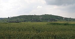
Tell es-Safi (bahasa Arab: تل الصافي, translit. Tall aṣ-Ṣāfī, "Bukit putih"; Ibrani: תל צפית, Tel Tzafit) adalah sebuah desa Palestina, yang terletak di tepi selatan Wadi 'Ajjur, 35 kilometer (22 mi) dari barat laut Hebron. Para penduduknya diusir pada Perang Arab–Israel 1948 atas perintah Shimon Avidan, panglima Brigade Givati.[4]
Referensi
- ↑ Morris, 2004, p. xix, village number #292. Also gives cause of depopulation
- 1 2 Government of Palestine, Department of Statistics. Village Statistics, April, 1945. Quoted in Hadawi, 1970, p. 50
- ↑ Department of Statistics, 1945, p. 23
- ↑ Morris, 2004, p. 436
Daftar pustaka
- Barron, J.B., ed. (1923). Palestine: Report and General Abstracts of the Census of 1922. Government of Palestine.
- Bliss, F.J.; Macalister, R.A.S. (1902). Excavations in Palestine During the Years 1898–1900. London. Pemeliharaan CS1: Lokasi tanpa penerbit (link) (pp. 28-43)
- Bliss, F.J. (1899). "Second Report on the Excavations at Tell Es-Safi". Quarterly Statement - Palestine Exploration Fund. 31: 317-333.
- Bliss, F.J. (1900). "Third Report on the Excavations at Tell Es-Safi". Quarterly Statement - Palestine Exploration Fund. 32: 16-86.
- Bromiley, G.W. (1982). International Standard Bible Encyclopedia. Vol. II: E-J. ISBN 0-8028-3782-4.
- Clermont-Ganneau, C.S. (1896). [ARP] Archaeological Researches in Palestine 1873-1874, translated from the French by J. McFarlane. Vol. 2. London: Palestine Exploration Fund. ( p.440. )
- Conder, C.R.; Kitchener, H.H. (1882). The Survey of Western Palestine: Memoirs of the Topography, Orography, Hydrography, and Archaeology. Vol. 2. London: Committee of the Palestine Exploration Fund.
- Department of Statistics (1945). Village Statistics, April, 1945. Government of Palestine.
- Guérin, V. (1869). Description Géographique Historique et Archéologique de la Palestine (dalam bahasa French). Vol. 1: Judee, pt. 2. Paris: L'Imprimerie Nationale. Pemeliharaan CS1: Bahasa yang tidak diketahui (link)
- Hadawi, S. (1970). Village Statistics of 1945: A Classification of Land and Area ownership in Palestine. Palestine Liberation Organization Research Center.
- Hastings, J.; Driver, S.R. (2004). A Dictionary of the Bible: Volume II: (Part I: Feign – Hyssop). The Minerva Group, Inc. ISBN 9781410217240.
- Hartmann, M. (1883). "Die Ortschaftenliste des Liwa Jerusalem in dem türkischen Staatskalender für Syrien auf das Jahr 1288 der Flucht (1871)". Zeitschrift des Deutschen Palästina-Vereins. 6: 102–149.
- Hütteroth, Wolf-Dieter; Abdulfattah, Kamal (1977). Historical Geography of Palestine, Transjordan and Southern Syria in the Late 16th Century. Erlanger Geographische Arbeiten, Sonderband 5. Erlangen, Germany: Vorstand der Fränkischen Geographischen Gesellschaft. ISBN 3-920405-41-2.
- Khalidi, W. (1992). All That Remains: The Palestinian Villages Occupied and Depopulated by Israel in 1948. Washington, D.C.: Institute for Palestine Studies. ISBN 0-88728-224-5.
- Le Strange, G. (1890). Palestine Under the Moslems: A Description of Syria and the Holy Land from A.D. 650 to 1500. London: Committee of the Palestine Exploration Fund.
- Macalister, R.A.S. (1925). A century of excavation in Palestine. London: The Religious Tract Society. (pp. 51, 56, 59, 124, 189, 275)
- Mills, E., ed. (1932). Census of Palestine 1931. Population of Villages, Towns and Administrative Areas. Jerusalem: Government of Palestine.
- Morris, B. (2004). The Birth of the Palestinian Refugee Problem Revisited. Cambridge University Press. ISBN 978-0-521-00967-6.
- Negev, Avraham; Gibson, S. (2005). Archaeological Encyclopedia of the Holy Land. Continuum International Publishing Group. ISBN 9780826485717.
- Palmer, E.H. (1881). The Survey of Western Palestine: Arabic and English Name Lists Collected During the Survey by Lieutenants Conder and Kitchener, R. E. Transliterated and Explained by E.H. Palmer. Committee of the Palestine Exploration Fund.
- Petersen, Andrew (2001). A Gazetteer of Buildings in Muslim Palestine (British Academy Monographs in Archaeology). Vol. 1. Oxford University Press. ISBN 978-0-19-727011-0. (pp. 291–292)
- Pringle, Denys (1997). Secular buildings in the Crusader Kingdom of Jerusalem: an archaeological Gazetter. Cambridge University Press. ISBN 0521 46010 7.
- Rey, E. G. [in Prancis] (1871). Etude sur les monuments de l'architecture militaire des croisés en Syrie et dans l'île de Chypre (dalam bahasa French). Paris: L'Imprimerie Nationale. Pemeliharaan CS1: Bahasa yang tidak diketahui (link)
- Robinson, E.; Smith, E. (1841). Biblical Researches in Palestine, Mount Sinai and Arabia Petraea: A Journal of Travels in the year 1838. Vol. 2. Boston: Crocker & Brewster.
- Robinson, E.; Smith, E. (1841). Biblical Researches in Palestine, Mount Sinai and Arabia Petraea: A Journal of Travels in the year 1838. Vol. 3. Boston: Crocker & Brewster.
- Schick, C. (1896). "Zur Einwohnerzahl des Bezirks Jerusalem". Zeitschrift des Deutschen Palästina-Vereins. 19: 120–127.
- Socin, A. (1879). "Alphabetisches Verzeichniss von Ortschaften des Paschalik Jerusalem". Zeitschrift des Deutschen Palästina-Vereins. 2: 135–163.
- Wigoder, Geoffrey (2005). The Illustrated Dictionary and Concordance of the Bible. Sterling Publishing Company, Inc. ISBN 9781402728204.
- Wilson, C.W., ed. (c. 1881). Picturesque Palestine, Sinai and Egypt. Vol. 3. New York: D. Appleton. (p.158 -p.161 )
Pranala luar
|
|---|
| Internasional | |
|---|
| Nasional | |
|---|
| Lain-lain | |
|---|


