Sumber: Lihat artikel asli di Wikipedia
Templat:List of castles and fortresses in Canton Aargau/location map
Templat:List of castles and fortresses in Canton Appenzell Ausserrhoden/location map
| Name | Image | Location | Type | Date | Notes |
|---|---|---|---|---|---|
| Rosenberg |  | Herisau-Burghalden 47°23′47″N 9°16′55″E / 47.3964°N 9.2819°E / 47.3964; 9.2819 | Ruined hill castle | about 1150 | Ruined castle |
| Rosenburg/Ramsenberg |  | Herisau 47°23′18″N 9°15′16″E / 47.3883°N 9.2544°E / 47.3883; 9.2544 | Ruined hill castle | about 1150 | Ruined castle |
| Kastel Urstein | Herisau 47°23′07″N 9°19′28″E / 47.38516°N 9.32438°E / 47.38516; 9.32438 | ||||
Templat:List of castles and fortresses in Canton Appenzell Innerrhoden/location map
| Name | Image | Location | Type | Date | Notes |
|---|---|---|---|---|---|
| Kastel Appenzell |  | Appenzell 47°19′48″N 9°24′35″E / 47.329947°N 9.409615°E / 47.329947; 9.409615 | Manor house | 1563 | Original owner Antoni Löw executed 1584. 1584-1682 used as Franciscan monastery. Today known as "Doctor's House" and privately owned. |
| Kastel Clanx | Appenzell 47°20′50″N 9°24′40″E / 47.347312°N 9.411171°E / 47.347312; 9.411171 | Ruined castle | 1219 | Burned during Appenzell Wars. Ruins rediscovered in 1885. | |
| Kastel Hoch-Altstätten | Oberegg 47°24′01″N 9°32′40″E / 47.40023°N 9.54442°E / 47.40023; 9.54442 | Ruins | |||
Templat:List of castles and fortresses in Canton Basel-Land/location map
Templat:List of castles and fortresses in Basel-Stadt/location map
| Name | Image | Location | Type | Date | Notes |
|---|---|---|---|---|---|
| Kastel Gundeldingen |  | Basel 47°32′24″N 7°35′32″E / 47.539944°N 7.592092°E / 47.539944; 7.592092 | Manor house | 14th century | Four castles of which parts remain of only two |
Templat:List of castles and fortresses in Canton Bern/location map Templat:List of castles and fortresses in Bern/location map
Templat:List of castles and fortresses in Canton Fribourg/location map
Templat:List of castles and fortresses in Canton Geneva/location map
Templat:List of castles and fortresses in Canton Glarus/location map
| Name | Image | Location | Type | Date | Notes |
|---|---|---|---|---|---|
| Vorburg |  | Glarus Nord 47°07′05″N 9°03′26″E / 47.118015°N 9.057323°E / 47.118015; 9.057323 | 13th century | Ruined castle | |
Templat:List of castles and fortresses in Canton Graubunden/location map
Templat:List of castles and fortresses in Canton Jura/location map
| Name | Image | Location | Type | Date | Notes |
|---|---|---|---|---|---|
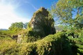
| Asuel Castle |  | La Baroche 47°23′57″N 7°12′36″E / 47.399154°N 7.210003°E / 47.399154; 7.210003 | Ruined castle | ||
| Löwenburg Castle |  | Pleigne 47°25′45″N 7°18′58″E / 47.42926°N 7.31617°E / 47.42926; 7.31617 | Ruined castle | 13th/14th century | |
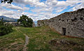
| Mont-Terri Castle |  | Cornol 47°23′28″N 7°09′40″E / 47.391222°N 7.161164°E / 47.391222; 7.161164 | Ruins | 1st century BC / 13th century | A ruined medieval castle above a prehistoric hillfort |
| Montvoie Castle | Clos du Doubs 47°21′57″N 7°03′24″E / 47.365919°N 7.056713°E / 47.365919; 7.056713 | ||||
| Prince-Bishops' Castle |  | Delémont 47°21′50″N 7°20′34″E / 47.363878°N 7.342824°E / 47.363878; 7.342824 | Château | 18th century | |
| Porrentruy Castle |  | Porrentruy 47°25′10″N 7°04′21″E / 47.419486°N 7.072403°E / 47.419486; 7.072403 | 13th century | Residence of the prince-bishops of Basel from 1527 until 1792, while they were in exile | |
Templat:List of castles and fortresses in Canton Lucerne/location map
Templat:List of castles and fortresses in Canton Neuchâtel/location map
Templat:List of castles and fortresses in Canton Nidwalden/location map
| Name | Image | Location | Type | Date | Notes |
|---|---|---|---|---|---|
| Rotzberg Castle |  | Rotzberg by Ennetmoos 46°57′51″N 8°20′11″E / 46.964207°N 8.336464°E / 46.964207; 8.336464 | hill castle, spur castle | 10th-12th century | Ruined castle |
| Schnitzturm |  | Stansstad 46°58′51″N 8°20′16″E / 46.980929°N 8.337663°E / 46.980929; 8.337663 | square tower | 1206/07 | |
Templat:List of castles and fortresses in Canton Obwalden/location map
| Name | Image | Location | Type | Date | Notes |
|---|---|---|---|---|---|
| Hexenturm |  | Sarnen 46°53′44″N 8°14′37″E / 46.895683°N 8.243706°E / 46.895683; 8.243706 | 1285/86 | built by the Niklaus and Heinrich Kellner. | |
| Landenberg Castle |  | Sarnen 46°53′48.16″N 8°14′37.94″E / 46.8967111°N 8.2438722°E / 46.8967111; 8.2438722 | 11th century | Ruined castle, 18th century armory and firing range built on site | |
| Rosenberg Castle |  | Giswil-Kleinteil 46°49′55.4″N 8°9′19.82″E / 46.832056°N 8.1555056°E / 46.832056; 8.1555056 | 13th century | Ruined bailiff's castle. | |
| Rudenz Castle |  | Giswil-Rudenz 46°49′57″N 8°11′04″E / 46.832366°N 8.184432°E / 46.832366; 8.184432 | hill castle, spur castle | 1200 to 1250 | Ruined castle, residence of ministeriales family. |
Templat:List of castles and fortresses in Canton Schaffhausen/location map
| Name | Image | Location | Type | Date | Notes |
|---|---|---|---|---|---|
| Herblingen Castle |  | Stetten 47°44′01″N 8°39′40″E / 47.7335°N 8.6612°E / 47.7335; 8.6612 | spur castle | 13th century | privately owned. |
| Hohenklingen Castle |  | Stein am Rhein 47°40′0″N 8°51′30″E / 47.66667°N 8.85833°E / 47.66667; 8.85833 | hill castle, spur castle | 1225 | residence of Freiherren. |
| Munot |  | Schaffhausen 47°41′49″N 8°38′23″E / 47.69694°N 8.63972°E / 47.69694; 8.63972 | 1563–1585 | City fortifications | |
| Wörth Castle |  | Neuhausen am Rheinfall 47°40′37″N 8°36′49″E / 47.676838°N 8.61363°E / 47.676838; 8.61363 | water castle | Built on a river island at the Rheinfalls | |
| Radegg Castle |  | 47°39′06″N 8°30′24″E / 47.651700°N 8.506615°E / 47.651700; 8.506615 | hill castle, spur castle | 13th Century | Ruined castle residence of Freiherren von Radegg, destroyed around 1300. |
Templat:List of castles and fortresses in Canton Schwyz/location map
| Name | Image | Location | Type | Date | Notes |
|---|---|---|---|---|---|
| Alt Rapperswil Castle | Altendorf 47°11′06″N 8°50′28″E / 47.184953°N 8.841181°E / 47.184953; 8.841181 | Ruins | before 1200 | ||
| Schwanau Castle |  | Lauerz 47°01′57″N 8°35′51″E / 47.032476°N 8.597395°E / 47.032476; 8.597395 | Ruins | about 12th century | |
| Gesslerburg |  | Küssnacht 47°04′55″N 8°26′55″E / 47.082018°N 8.448663°E / 47.082018; 8.448663 | hill castle | about 9th century | Ruined castle |
| Grynau Castle |  | Tuggen 47°12′59″N 8°58′13″E / 47.216324°N 8.970278°E / 47.216324; 8.970278 | early 13th century | Today a country inn | |
| Pfäffikon Castle |  | Freienbach 47°12′18″N 8°46′25″E / 47.20499°N 8.77357°E / 47.20499; 8.77357 | water castle | 13th century | Built by Einsiedeln Abbey as an abbot's residence |
Templat:List of castles and fortresses in Canton Solothurn/location map
Templat:List of castles and fortresses in Canton St. Gallen/location map
Templat:List of castles and fortresses in Canton Ticino/location map
Templat:List of castles and fortresses in Canton Thurgau/location map
Templat:List of castles and fortresses in Canton Uri/location map
Templat:List of castles and fortresses in Canton Vaud/location map
Templat:List of castles and fortresses in Canton Valais/location map


.jpg)


_174.JPG)


_509.JPG)
_259.JPG)


_066.JPG)


.jpg)


.jpg)


_300.JPG)


.jpg)


.jpg)


.jpg)


.jpg)


.jpg)